

Landscape for living
Launch for your suburbs vegetation cover
Launch OPO using your desktop
Coming Soon
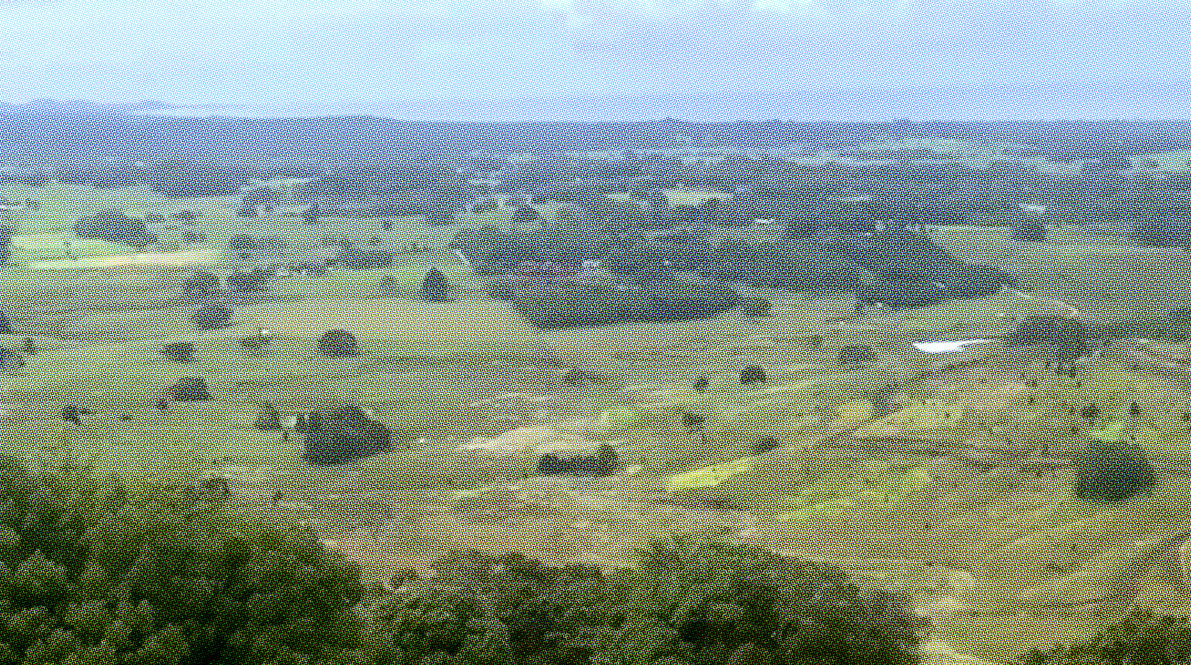
Urban Greening
Webtool
Landscape Architecture integrated with architecture, site and lifestyle.


Most landholders know they want to improve their land.
Few know where to start.
Regeneration often focuses on planting, compliance or carbon outcomes.
Liff helps you understand the whole property — from the house and lived landscape through to ecological restoration — creating a clear pathway forward.
Most Landholders Don't
Know Where To Start


Early landscape thinking
Key moves up front
Reduce re-design risk
Achieve:
Cohesive whole of site
Collaborative results
Experience:
The design journey
Brief & budget being met
Commitment to excellence
Roadmap to success
Best for:
3.
2.
1.
The landscape is often where people spend most of their time, yet it is frequently considered late in the design process.
We work with architects and landholders to create cohesive living environments, bringing landscape thinking into projects early and ongoing. Helping align architecture, site, budget and client aspirations into a unified vision.
Delivery
Integrate
Clarify
What We Do

Find your property clarity
Regeneration is more than planting trees. Start with understanding how the whole property works and let design guide your property decision making, towards a landscape in coherence.
Get clarity on where to start, priorities and opportunity
Frame & plan actions linked with capital & timing
Design increasing amenity, beauty and regeneration
Are you asking what should I do with my land?
Take the Survey find and find out the top x3 reccomendations

Working with aligned clients across South East Queensland & Northern Rivers - wider Australia & New Zealand

- Do you have acerage and wondering what to do?
- Have you recently bought land, thinking where to start with the budget you have?
- Are you keen to regenerate or rewild but want it to look beautiful?

Recieve:
Masterplan
Take the right step at the right time and build confidence for the journey ahead.
Understand the key moves, sequence decisions effectively, and ensure your investment contributes to your daily lived experience.
Confidence in the build
Documented resolution
High-End design thinking
Recieve:
Character Zoning
Existing Conditions
Recieve:
Clear key moves plan
Design theme & approach
Collaborative design session
We carry out all phases of the design process from Schematic Design through to Documentation and CA.
Delivering on design excellence and to the fundamental brief/budget.
A long-term masterplan aligning customer needs with a wider property vision. A clear 2–5+ year roadmap ensuring high-quality outcomes that enhance both land value and everyday activities.
Check how landscape is integrated with the architecture. You'll recieve. a four page report ensuring alignment and key moves are set before bigger design packages.
3. Design
2. Masterplan
1. Return Brief
Our Services
We work with aligned landholders, becoming part of the team, committed to excellence and the final result
Environmental resillience
Enhance Biodiversity
Increase Property Value
Planning investment into nature focused development


Rural owners creating long-term landscape plans
Private residents seeking to regenerate their land
Landholders
Legacy
Lifestyle
Who We Work With
Working with aligned clients across South East Queensland & Northern Rivers - wider Australia & New Zealand
Contact Us
Liff Studio
Liff Studio is led by Thomas Gooch, a Landscape Architect with over two decades of experience across high-end residential, civic and public realm projects.
His work spans Melbourne's Greenline redevelopment through to private residential landscapes across South East Queensland and the Northern Rivers, along with international experience.
Liff Studio combines strategic thinking, design excellence and practical delivery experience to create places that are beautiful, enduring and connected to site.
We are intentionally selective.
Projects are led personally, approached with care, and long time horizons.
We value alignment over scale and depth over speed, pursuing beauty in all we do.
Who We Are
How We Work
About us

Follow Us
Stay in Touch
We recognise the traditional owners of the land where we work, their elders past and present and their relationship with the landscape.
We recognise the Earth’s right to exist in its integrity, with all planetary boundaries intact and healthy so that all life on Earth can be sustained.


OUR HAPPY CLIENTS


OUR PARTNERS

And get a quote for your next project
100% free, no obligation
Business as Usual
Report on Impact
Actionable Insights
Data Collection
Cost
Speed
Improved operations by 600% - underpin decisions with regular data
Time series analysis; tasking and historical
A fraction of the cost
Get Insights in Under 4 Weeks
No visibility on impact
Low to no data interpretation beyond data acquisition
Typically one data capture
High
Data takes 6+ months
-v5.png)
-v5.png)
-v4.png)
-v4.png)
Nature Data AI Platform
Old Way to Collect & Report on Data
How our In-House Nature Data AI Compares

- Have you recently bought land, thinking where to start with the budget you have?
- Are you keen to regenerate or rewild but want it to look beautiful?
- Do you have acerage and wondering what to do?
Why Seek Coherence

And get a quote for your next project
100% free, no obligation
Tasking ahead of time
Historical back-casting
Identify Trends
Carbon Value
Sequestered Carbon
Urban Forest
Contextual Position
Cooling Effects
Connectivity
Modelling
For Habitat Connectivity
For Urban Heat Islands
Contextual Position
Cooling Effects
UHI Hot/Cool Spots
Loss/Gain
Tree Health
Canopy %
Time Series Analysis
Valuations
Green Infrastructure
Tree Planting Opportunities
Land Surface Temperature
Tree Canopy Mapping


Key Insights From Our
In-House Nature Data AI Platform

Lorem ipsum dolor sit amet, consectetur adipiscing elit, sed do eiusmod tempor incididunt ut labore et dolore magna aliqua.


Director at The Thinker
Shepparton Council
Lorem ipsum dolor sit amet, consectetur adipiscing elit, sed do eiusmod tempor incididunt ut labore et dolore magna aliqua.
Director at The Thinker
Shepparton Council
Lorem ipsum dolor sit amet, consectetur adipiscing elit, sed do eiusmod tempor incididunt ut labore et dolore magna aliqua.
Director at The Thinker
Shepparton Council
What Our Customers Say
Chief Growth Officer for Active Tree Services
Simon Strauss
“I’m Chief Growth Officer for Active Tree Services. We work with LGA’s around the country on urban forest strategy (UFS) development, canopy forecast modelling and planning.
Prior to working with OPO, tree canopy mapping and Urban Heat Island metrics we use to benchmark (and KPI) UFS had been sourced from overseas space technology businesses or via government portals. The quality was highly variable and required extensive, time-consuming re-processing.
Initially, I was unsure about using OPO because of our, and our clients, requirements for quality and timeliness along with the specialised IP needed to be able to deliver strong outcomes at the requisite accuracies.
OPO have not only made it possible to source satellite and AI processed imagery locally for the first time, they’ve done so affordably, with great communication and responsiveness. This has meant we’ve been able to service both urban and regional councils who have smaller sustainability-related budgets than the major LGA’s yet are still wanting to manage their urban forests, heat risk and tree planting programs; underpinned with data.
The best part of OPO is their ability to partner, bringing their deep understanding of the industry and science to the table. This has meant being able to both utilise pre-prepared products and develop new product offerings in line with client needs.”
And get a quote for your next project
100% free, no obligation
Ability to view historical and ongoing trends over long time periods. Use this to inform captial works decisions, budgets and programs.
Long Term Management

If you need custom data sets, we work with you to provide custom analysis, insights and actions - particular to your project needs.
Customisation

Don't be left wondering what to do. We make clear the actions needed to ensure your Nature Positive next steps - underpinned with data.
Actionable Insights & Reports
If you already have high resolution imagery, we use our in-house AI to create the analysis, then we also create the insights and actions for you.
Supply your own Imagery
We make Nature Data readily available and easy to act on. Growing our software to service your everyday needs, and the needs of Nature.
Nature Data Made Easy
5 Reasons Customers Choose
Our Nature Data Platform
Frequently Asked Questions
Book your free demo today where we will walk you through how the product works, and the subscription tiers available to you. 100% free, no obligation.
If you decide to sign up, we can assist you with on-boarding, then away you go!
We're currently servicing annual subscriptions for either 5, 20 or 100 sqkm areas (Contact us for more). Once signed up, you'll have this many sqkm to use up over the year. If all km are used prior to the year ending - you can always top-up to ensure your measuring, monitoring and reporting neads are met.
We also have a minimum sqkm purchase for each tiered subscription. 'Starter' is 1 sq km minimum purchase, 'Pro' is 2 sq km min purchase and 'Pro-Max' is 5 sq km purchase.
Yes!
However, sometimes clouds get in the way, so imagery may not be available, or it may not have been captured in your area at the time you want.
If this is the case, we can task imagery to capture it in the futue to ensure your insights, actions and reporting is up-to-date.
But don't worry, there's usually imagery over most areas - especially major cities and towns.
We know you want to get on and plan, design and maintain our cities.
So our insights help you understand how your data sits with best practice of the day, where trees are lacking or coverage has increased. Where urban heat islands are, habitat corridors are located or where to plant and number of trees. The actions help then understand where issues are arising, or how to improve your project site immediately and on-going.
We appreciate that receiving your nature data analysis, insights and actions is just the start.
You then need to export the data, maps and reports into your workflow. This could be in the office, studio or on-site, so we have full reports you can download and include into policy, planning and reporting. Or export maps to do similar, and to use when on-site or in the field.
We're kicking off with a focus on Greening our cities, but we can also help you with your nature data reporting needs - whatever they may be.
This could be linked with corporate reporting, meeting science based targets, asset management or other requirements.
Reach out to us to enquire, as we're doing alot behind that scenes that could help you.
Our commitment to service doesn't end with product delivery. We'll follow up with you to provide support and ensure that you have everything you need to effectively ingest and incorporate your data insights into your daily operations.
With our expertise, cutting-edge technology, and dedication to making a positive impact, you can trust that we’re there to support your greening efforts and drive meaningful change.
And get a quote for your next project
100% free, no obligation

AS SEEN IN
And get a quote for your next project
100% free, no obligation
Ready To Fast Track Your
Greening Initiatives?


Follow Us
.png)
.png)